FPL Selection for Data Centres: Ensuring Mission-Critical Resilience
In my two decades of managing civil and piping infrastructure for hyperscale facilities, I have learned that the Flood Protection Level (FPL) is not merely a regulatory checkbox; it is the primary determinant of site survivability. When we design for data centres, we are not just protecting steel and concrete; we are safeguarding the digital backbone of global commerce.
Selecting an appropriate FPL requires a deep dive into local flood maps, historical precipitation data, and the specific hydraulic constraints of the site. If you miscalculate the freeboard or ignore adjacent infrastructure tie-ins, you risk catastrophic downtime that no amount of redundant power can fix. This guide breaks down the engineering rigor required to establish a robust FPL strategy.
Key Takeaways for Engineering Teams:
- Prioritize site-specific hydrologic modeling over generic FEMA flood maps.
- Integrate freeboard requirements that account for climate-adjusted storm surge projections.
- Coordinate utility entry points with the established FPL to prevent subterranean flooding.
- Evaluate the impact of adjacent site development on your facility’s drainage capacity.
Technical Deep-Dive: FPL Selection for Data Centres
FPL Selection for Data Centres: The systematic application of hydraulic engineering principles to establish a design flood elevation that exceeds the 500-year flood event, incorporating site-specific risk factors and climate resiliency standards.
When I approach FPL selection, I start by evaluating the ASCE 24 standards for flood-resistant design. For mission-critical facilities, the standard 100-year flood (Base Flood Elevation) is insufficient. We must design for the 500-year event or higher, depending on the facility’s Tier rating and the client’s risk appetite.
Hydraulic Modeling and Freeboard Calculations
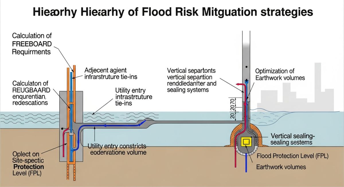
The FPL is calculated as the Base Flood Elevation (BFE) plus a mandatory freeboard. In my experience, a minimum of 2 to 3 feet of freeboard is standard, but for data centres, I often push for 4 feet to account for wave action and debris accumulation. The calculation follows the basic energy equation where the total head at the site must remain below the critical entry points of the facility.
Calculation Parameters:
- Determine BFE from local FEMA Flood Insurance Rate Maps (FIRM).
- Apply a climate change factor (CCF) to the peak discharge (Q) of the 500-year storm.
- Calculate the water surface elevation (WSE) using Manning’s equation for open channel flow.
- Add the freeboard (FB) to the WSE to arrive at the final FPL.
Field Warning: Utility Entry Constraints
Subterranean utility conduits are the most common failure points. Even if the building pad is elevated, a flood can enter through fiber optic vaults or power duct banks. Ensure all penetrations are sealed with hydrostatic-rated seals and that entry points are located above the FPL.
Earthwork considerations are equally vital. We must balance the site to ensure that the fill required to reach the FPL does not negatively impact the flood storage capacity of the surrounding floodplain. If we displace water, we must provide compensatory storage elsewhere on the site to avoid violating local environmental permits.
Strategic FPL Implementation: The comparative analysis of elevated site design versus perimeter flood barrier systems in the context of long-term facility operational continuity.
Advantages
- Eliminates reliance on active mechanical flood barriers.
- Reduces long-term insurance premiums for mission-critical assets.
- Provides a passive, fail-safe defense against extreme weather.
- Enhances site drainage by utilizing natural gravity flow.
- Increases the overall asset value and marketability of the facility.
Disadvantages
- Significant initial capital expenditure for site grading and fill.
- Potential for increased site footprint due to slope requirements.
- Complex permitting processes for floodplain modification.
- Risk of creating “island effects” if surrounding roads flood.
- Requires extensive geotechnical stabilization for elevated pads.
Infrastructure Resilience Deployment: The practical application of high-elevation FPL standards across diverse industrial and digital infrastructure sectors to mitigate climate-related operational risks.
Hyperscale Data Centre Campuses
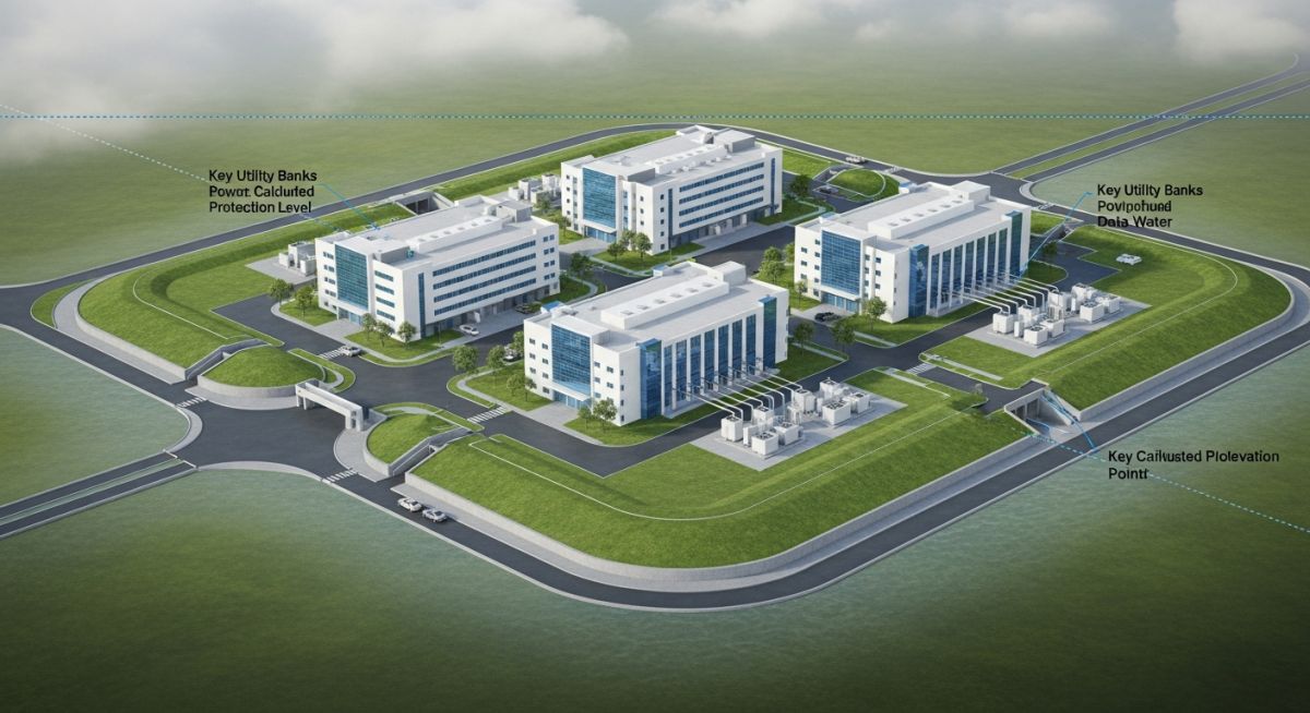
For massive campuses, we utilize a site-wide FPL strategy that elevates the entire building pad. This approach ensures that all critical power and cooling infrastructure remains operational even during a 500-year flood event, preventing the need for emergency shutdowns.
Coastal Edge Computing Facilities
In coastal regions, FPL selection must account for both storm surge and sea-level rise. We implement elevated structural steel platforms for critical equipment, ensuring that the FPL is calculated based on projected 50-year sea-level rise scenarios.
Brownfield Industrial Redevelopment
When converting existing industrial sites, we often face limited space for grading. Here, we use a combination of perimeter flood walls and internal site elevation to meet the FPL, ensuring that the facility remains protected without disrupting adjacent infrastructure.
When establishing the Flood Protection Level (FPL) for mission-critical data centre facilities, engineers must synthesize historical hydrological data with projected climate-resilient site elevations. The following table delineates the critical design parameters that dictate site selection and structural elevation, ensuring that the facility remains operational during extreme weather events. These values are derived from ASCE 24 standards, which govern flood-resistant design and construction in flood-prone areas.
It is imperative to note that the “Design Freeboard” column represents the additional vertical buffer added to the Base Flood Elevation (BFE). In my experience, relying solely on the 100-year flood event is insufficient for hyperscale data centres; we must account for the 500-year event or higher to maintain Tier IV uptime requirements. The interaction between local topography and regional drainage infrastructure often necessitates a site-specific hydraulic analysis to validate these baseline assumptions before finalizing the civil grading plan.
| Parameter | Standard/Reference | Recommended Value |
|---|---|---|
| Base Flood Elevation (BFE) | FEMA FIRM | 100-Year Event (1% Annual Chance) |
| Design Freeboard | ASCE 24-14 | 2 to 3 Feet Above BFE |
| Critical Facility FPL | Local Building Code | 500-Year Event (0.2% Annual Chance) |
The following matrix maps the core technical entities involved in FPL selection for data centres. By aligning structural, hydrological, and regulatory components, we create a comprehensive framework for site resilience. This mapping is essential for project stakeholders to understand how individual site constraints, such as utility entry points or adjacent infrastructure, influence the overall flood mitigation strategy.
In my professional practice, I have observed that failure to integrate these entities early in the design phase leads to costly retrofits or, worse, catastrophic downtime during extreme weather. The matrix below serves as a quick-reference guide for project managers and civil engineers to ensure all regulatory and physical requirements are addressed during the site feasibility study and subsequent design development stages.
FPL Selection for Data Centres requires a rigorous verification process to ensure that the facility remains protected against both current and future flood risks. This checklist provides a structured approach for civil engineers to validate site conditions against the established FPL requirements.
- Topographic Survey Validation: Ensure the site survey is performed to NAVD88 vertical datum and verified against local benchmarks.
- Hydraulic Modeling Review: Confirm that the 500-year flood model accounts for future climate change projections and potential upstream development.
- Utility Entry Point Elevation: Verify that all critical utility penetrations, including fiber optics and power conduits, are located at or above the FPL plus freeboard.
- Adjacent Infrastructure Assessment: Evaluate the impact of neighboring site drainage and potential backwater effects on the facility’s perimeter.
- Emergency Access Routes: Confirm that primary and secondary access roads remain passable during a 100-year flood event.
- Stormwater Management System: Validate that the detention basin capacity meets local requirements for the design storm event.
Each item on this list must be signed off by the lead civil engineer. In my experience, the most common point of failure is the utility entry point; even if the building is elevated, a single low-lying conduit can act as a conduit for floodwater to enter the server halls. Always prioritize the sealing of all sub-grade penetrations with hydrostatic-rated seals.
Field Case Study: Real-World Application
The Problem: Inadequate FPL and Utility Vulnerability
A hyperscale data centre project faced significant risk due to an underestimated FPL during the initial site selection phase.
- Initial design relied on outdated 100-year flood maps.
- Utility conduits were installed at grade, ignoring potential hydrostatic pressure.
- Adjacent site development increased runoff coefficients, overwhelming existing drainage.
- Lack of freeboard resulted in potential water ingress during minor storm events.
The Outcome: Successful Mitigation and Resilience
By implementing a comprehensive FPL re-evaluation, the project team successfully secured the facility against future risks.
- Elevated the entire building pad by 3.5 feet to exceed the 500-year flood level.
- Installed hydrostatic-rated seals on all underground utility penetrations.
- Constructed a perimeter flood wall integrated with the site’s landscaping.
- Achieved Uptime Institute Tier IV certification for flood resilience.
My recommendation for similar projects is to always conduct a “worst-case” scenario analysis. Do not rely on historical data alone; incorporate predictive modeling that accounts for urban growth and changing weather patterns. The cost of elevating a site during the earthwork phase is a fraction of the cost of a single hour of downtime.
Frequently Asked Engineering Questions
Why is the 500-year flood event preferred for data centres?
- The 500-year event provides a significantly higher safety margin against climate-induced extreme weather.
- Insurance requirements for Tier III and IV facilities often mandate protection against the 0.2% annual chance flood.
- It minimizes the risk of business interruption, which is the primary driver for data centre design.
How do I calculate the required freeboard for my site?
- Assess local flood hazards, including wave run-up and debris impact.
- Review regional building codes, which may mandate higher freeboard requirements than national standards.
- Consider the sensitivity of the facility’s electrical and mechanical equipment located at the ground level.
What are the risks of adjacent infrastructure tie-ins?
- Backwater effects from undersized culverts can raise water levels on your property.
- Shared drainage systems may become overwhelmed during peak storm events.
- Utility tie-ins can act as conduits for floodwater if not properly sealed at the property line.
How does earthwork affect flood protection levels?
- Ensure that fill material is compacted to prevent settlement, which could lower the effective FPL over time.
- Verify that the site grading does not negatively impact the flood storage capacity of the surrounding area.
- Consider the use of retaining walls if space constraints limit the footprint of the elevated pad.
What are the constraints for utility entry points?
- All penetrations must be sealed with hydrostatic-rated, water-tight seals.
- Utility vaults should be designed with sump pumps and water-tight covers.
- Avoid locating utility entry points in low-lying areas of the site.
How do I optimize the FPL selection process?
- Evaluate multiple site options to identify those with naturally higher elevations.
- Use cost-benefit analysis to determine the optimal level of protection versus the cost of mitigation.
- Engage with local authorities early to understand regulatory requirements and potential incentives for resilient design.
Complete Course on
Piping Engineering
Check Now
Key Features
- 125+ Hours Content
- 500+ Recorded Lectures
- 20+ Years Exp.
- Lifetime Access
Coverage
- Codes & Standards
- Layouts & Design
- Material Eng.
- Stress Analysis

📚 Recommended Resources: Data Centres
Read these Guides
- 📄 Geotechnical Requirements for Data Centres: A Structural Engineering Guide
- 📄 Future of High-Density Data Centres: AI, Sustainability, and Power
- 📄 Renewable Energy for Data Centres: Engineering Sustainable Infrastructure Solutions
- 📄 Battery Energy Storage Systems for Data Centres: Engineering Design Guide