Table of Contents

Understanding Land Mapping and the True Topographic Survey Cost
In my 20+ years of managing major civil infrastructure and piping projects, I have seen countless developers make the fatal mistake of skipping or underfunding their initial site mapping. They treat land surveying as a mere administrative box to check, only to face millions of dollars in structural foundation failures or pipeline alignment clashes later. When you are designing drainage systems, grading plans, or routing heavy industrial piping, you need absolute spatial precision. Understanding the true topographic survey cost upfront is not just about budgeting; it is about mitigating catastrophic engineering risks before the first excavator ever touches the dirt.
Key Engineering Takeaways:
- Accurate elevation data prevents costly foundation redesigns and drainage failures.
- The total topographic survey cost varies based on acreage, terrain density, and required contour intervals.
- Standard compliance with NSPS standards ensures legal and engineering validity for municipal approvals.
Key Factors Influencing Your Topographic Survey Cost
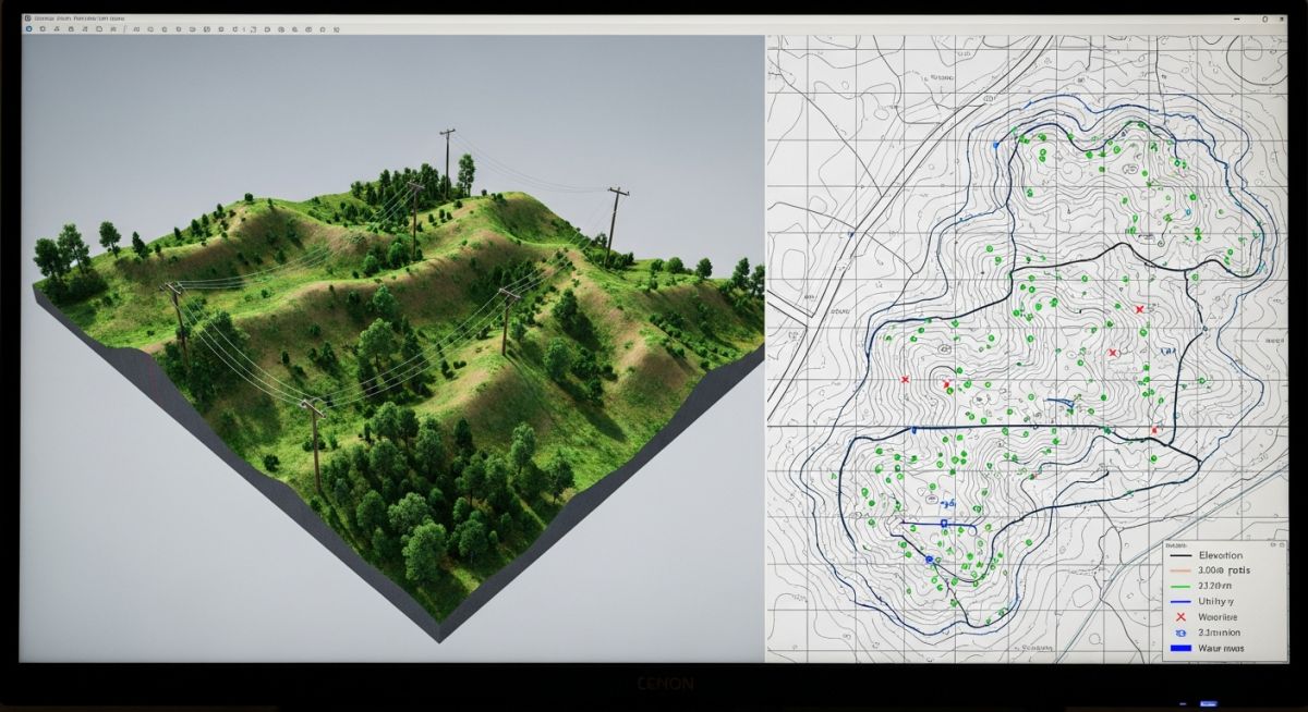
To accurately estimate the topographic survey cost for any civil or piping project, we must break down the technical parameters that dictate field hours. Surveyors do not just walk a site with a GPS rover; they establish a highly precise control network. The density of vegetation, the steepness of the terrain, and the required contour interval resolution directly impact the time spent on-site. For instance, a 1-foot contour interval requires significantly more data points than a 5-foot contour interval, directly increasing the drafting and field collection time.
The Mathematics of Contour Interpolation
To calculate the exact horizontal position of a contour line between two measured elevation points, we use linear interpolation. Let Point A have an elevation of 102.4 meters and Point B have an elevation of 105.8 meters. The horizontal distance between them is 15.0 meters. If we want to find the exact location of the 104.0-meter contour line:
2. Calculate elevation difference from Point A to target contour: 104.0 – 102.4 = 1.6 meters
3. Calculate horizontal distance from Point A to the contour line:
Distance = (Total Distance * Elevation Difference to Contour) / Total Elevation Difference
Distance = (15.0 * 1.6) / 3.4 = 7.06 meters
This mathematical precision ensures that our grading plans and piping alignments match the physical reality of the site. Any error in this interpolation can lead to pooling water or incorrect pipe slopes, which is why hiring licensed professionals who follow ASCE guidelines is non-negotiable.
How to Estimate Your Topographic Survey Cost
When budgeting for land development, you must understand how scale and complexity scale the pricing. Below is a realistic breakdown of costs based on typical project parameters I have managed across various industrial and residential sites.
| Project Scale | Typical Acreage | Terrain Complexity | Average Cost Range (USD) | Primary Equipment Used |
|---|---|---|---|---|
| Small Residential | 0.25 to 1 Acre | Flat, Clear | 800 – 2,000 | Total Station, RTK GPS |
| Medium Commercial | 1 to 5 Acres | Moderate Vegetation | 2,500 – 6,000 | Robotic Total Station, 3D Scanner |
| Large Industrial | 5 to 20 Acres | Heavy Brush, Slopes | 6,500 – 15,000 | LiDAR Drone, Ground Control RTK |
| Infrastructure Corridor | Linear (Piping/Roads) | Variable, Complex | 10,000 – 30,000+ | Mobile LiDAR, Terrestrial Scanning |
Technical Mapping & Specifications Matrix
To ensure your survey is legally compliant and technically viable for engineering design, it must map specific physical entities. The table below outlines these critical entities and their corresponding standards.
| Survey Entity | Technical Acronym | Physical Parameter Measured | Standard Reference | Engineering Application |
|---|---|---|---|---|
| Benchmark Elevation | BM | Vertical Datum Height (NAVD88) | NGS Standards | Foundation leveling, structural design |
| Right of Way | ROW | Horizontal property boundaries | ALTA/NSPS Land Title | Utility routing, setback compliance |
| Invert Elevation | IE | Lowest inside point of pipe/channel | ASCE 38-02 | Gravity sewer and storm drain design |
| Ground Control Point | GCP | X, Y, Z coordinate calibration | FGDC Accuracy Standards | Drone photogrammetry calibration |
Field Verification Checklist for Survey Accuracy
Before you sign off on a surveyor’s deliverable and release payment, you must verify that the data is technically sound. As a project manager, I use this exact checklist to audit incoming CAD files and survey reports.
Topographic Survey QA/QC Checklist:
-
Datum Verification: Confirm that the survey references the correct horizontal datum (typically NAD83) and vertical datum (typically NAVD88).
-
Control Point Loop Closure: Ensure the surveyor provides a loop closure report showing a vertical error of closure within acceptable limits (typically 0.05 feet times the square root of the distance in miles).
-
Utility Invert Mapping: Verify that all storm and sanitary sewer manholes show invert elevations, pipe sizes, and materials, rather than just surface rim elevations.
-
Contour Line Smoothness: Check CAD files for jagged or overlapping contour lines, which indicate interpolation errors or bad data points.
-
Tree Canopy Penetration: For wooded sites, confirm that ground shots were taken manually where dense foliage prevents GPS or LiDAR from reaching the actual soil surface.
Field Case Study: Real-World Application
The Problem: The Cost of a Cheap Survey
On a 12-acre industrial chemical plant expansion in Louisiana, the client opted for a low-bid surveyor to minimize their initial topographic survey cost. The surveyor relied heavily on uncalibrated drone photogrammetry without establishing adequate ground control points in a marshy, heavily vegetated zone. During the piping design phase, we relied on these contours to route a 24-inch gravity-flow wastewater line. Once construction began, we discovered the actual ground elevations were 1.4 feet lower than mapped, meaning the wastewater line would have had to flow uphill to reach the treatment facility.
The Outcome: Remediation and Savings
I immediately halted excavation and brought in a premium surveying crew equipped with robotic total stations and terrestrial LiDAR. We executed a highly precise topographic re-survey costing 8,500. The new data allowed us to redesign the piping slope and add a small lift station. While the re-survey and redesign added 15,000 to the engineering budget, it saved the client over 180,000 in potential field rework, trench backfilling, and structural foundation modifications that would have occurred had we proceeded with the faulty initial data.
The lesson here is clear: attempting to cut corners on your initial topographic survey cost almost always results in exponentially higher construction change orders. Invest in high-quality, licensed surveying from day one.
Frequently Asked Engineering Questions
What is the difference between a boundary survey and a topographic survey?
How long does a topographic survey remain valid for engineering design?
What specific equipment is used to determine topographic survey cost?
Can drone photogrammetry completely replace traditional ground-based topographic surveys?
How do contour intervals affect the overall topographic survey cost?
What are the standard accuracy tolerances for civil engineering topographic surveys?
===
Complete Course on
Piping Engineering
Check Now
Key Features
- 125+ Hours Content
- 500+ Recorded Lectures
- 20+ Years Exp.
- Lifetime Access
Coverage
- Codes & Standards
- Layouts & Design
- Material Eng.
- Stress Analysis

📚 Recommended Resources: topographic survey cost
Read these Guides
Related posts:
![Side-by-side comparison of an industrial centrifugal pump and a rotary screw compressor.]()
What is the Difference Between Pump and Compressor Systems?
![Cutaway 3D render of an industrial air-operated double-diaphragm pump showing internal components.]()
Understanding Diaphragm Pumps: A Comprehensive Guide for Industrial Plants
![A metallic pipe sleeve embedded in a concrete wall with a carrier pipe passing through it.]()
What is a Pipe Sleeve and How Does It Protect Piping?
![Industrial stainless steel swing check valve installed in a pipeline with a flow direction arrow.]()
What are Check Valves? Types of Check Valves & Their Symbols
![Cross-section diagram of a control valve showing cavitation bubbles and flashing liquid.]()
How to Prevent Control Valve Cavitation and Flashing Damage
![Side-by-side comparison of ASME Section VIII Division 1 and Division 2 pressure vessels with technical blueprints.]()
Understanding the Difference Between ASME Sec VIII Div 1 vs Div 2