Pipeline Route Survey Challenges: Engineering Risk Mitigation
Mitigating Pipeline Route Survey Challenges is the single most critical factor in preventing budget blowouts and schedule delays in midstream capital projects. While the shortest distance between two points is a straight line, the reality of Geohazard Risk Assessment, complex land acquisition laws, and strict environmental regulations rarely permits a linear path. In 2026, engineers must navigate a minefield of technical and non-technical constraints to define a constructible Right of Way (RoW).
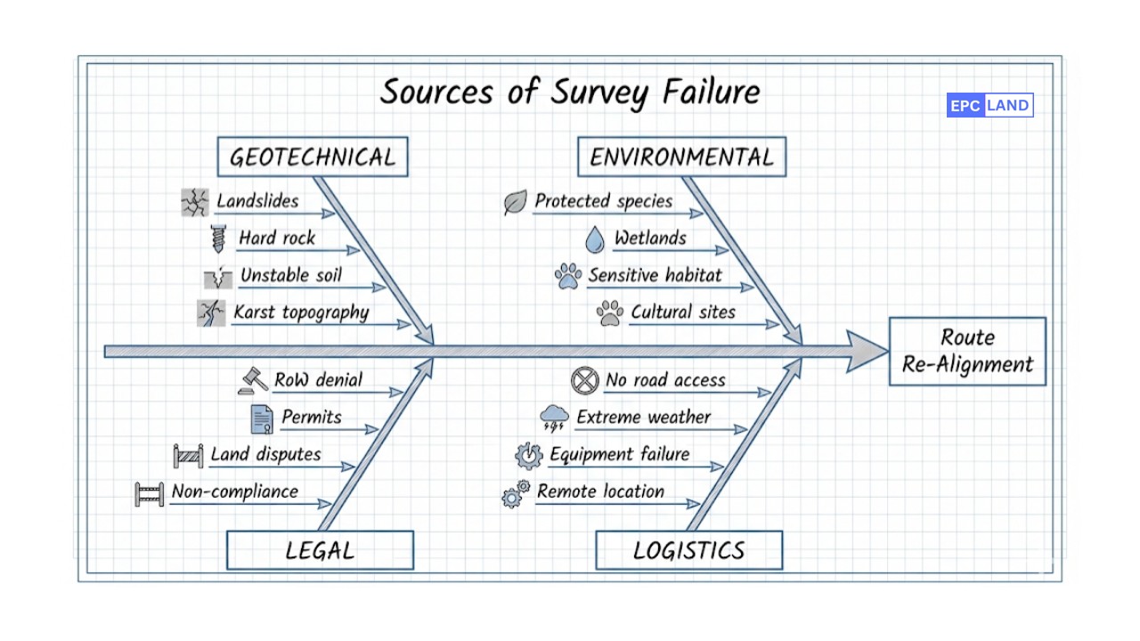
The “Triple Constraint” of Route Surveys
Survey challenges typically stem from the conflict between three opposing forces: 1) Physical Constraints (Topography, Geotech), 2) Social Constraints (RoW, Urbanization), and 3) Regulatory Constraints (EIA, Permits). A failure in any one pillar can force a multi-million dollar “Route Re-Alignment.”
Knowledge Check: Survey Risks
Question 1 of 5Loading…
Risk Analysis:
Complete Course on
Piping Engineering
Check Now
Key Features
- 125+ Hours Content
- 500+ Recorded Lectures
- 20+ Years Exp.
- Lifetime Access
Coverage
- Codes & Standards
- Layouts & Design
- Material Eng.
- Stress Analysis

Category 1: Geotechnical & Terrain Constraints
Among the myriad of Pipeline Route Survey Challenges, physical geography poses the most immediate threat to construction feasibility. In 2026, as pipelines are pushed into more remote and marginal lands, the risk of Pipeline Route Geotechnical Uncertainty increases exponentially.
Geohazard Risk Assessment
A robust Geohazard Risk Assessment is non-negotiable for routes traversing mountainous or seismically active regions. Surveyors must identify “Red Flag” zones such as active faults, liquefaction-prone soils, and ancient landslide scars. Failure to map these features leads to route instability, where ground movement can exert excessive longitudinal strain on the pipe, leading to buckling or rupture.
Inaccessible Terrain Survey Methods
Traditional “boots on the ground” methods often fail when the route encounters steep cliffs (gradients > 30%) or dense swamps. To overcome this, modern engineers employ Inaccessible Terrain Survey Methods utilizing heavy-lift drones equipped with LiDAR and bathymetric sensors. These unmanned systems can map the terrain from a safe altitude, penetrating vegetation cover to reveal the true ground profile without endangering personnel.
Category 2: Regulatory & Social Obstacles
Often, the ground is stable, but the legal framework is shaky. Right of Way (RoW) Acquisition Issues are frequently cited as the #1 cause of project cancellation. If a landowner denies survey access, the engineering team cannot validate the route, leading to massive detours (re-routes) that add kilometers to the pipeline length and millions to the CAPEX.
Furthermore, Environmental Impact Assessment (EIA) Constraints define “No-Go Zones.” Surveyors must work closely with biologists to map wetlands, migratory bird nests, and archaeological sites. A Pipeline Route Survey that ignores these constraints will inevitably fail during the permitting phase, triggering regulatory shutdowns.
Subsurface Utility Engineering (SUE)
In brownfield or urban environments, the challenge shifts from nature to man-made chaos. Subsurface Utility Engineering (SUE) is the discipline of mapping existing underground infrastructure (water, gas, fiber optics). The survey team must utilize Ground Penetrating Radar (GPR) and electromagnetic locators to assign a “Quality Level” (A through D) to utility data, preventing catastrophic strikes during trenching.
🧮 Engineering Calculation: Slope Stability Factor of Safety
When a route traverses a slope, the survey data is used to calculate the Factor of Safety (FS) against sliding. An FS less than 1.5 usually requires route realignment or expensive stabilization.
Where:
- FS = Factor of Safety (Dimensionless)
- c = Cohesion of soil (kPa) – Derived from Geotech Labs
- σ = Normal Stress on the slip surface (kPa)
- φ = Angle of Internal Friction (degrees)
- τ = Shear Stress driving the slide (kPa)
Note: If the survey reveals high τ (steep slope) and low c (loose soil), the FS will drop below 1.0, indicating immediate failure risk.
Mitigation Matrix: Matching Challenge to Solution
The following table outlines how top EPC firms address common Pipeline Route Survey Challenges using 2026 technologies and standards.
| Challenge Category | Specific Risk | Mitigation Technology | Standard / Ref |
|---|---|---|---|
| Geohazards | Landslides / Slope Failure | LiDAR Change Detection & Inclinometers | ISO 20074 |
| Access Denial | Landowner blocks entry | Drone Aerial Photogrammetry (Remote) | FAA Part 107 / Local Aviation Law |
| Water Crossings | Scour exposing pipe | Multi-beam Sonar Bathymetry | USACE Hydrographics |
| Urban Clutter | Utility Strikes | SUE (GPR + Vacuum Excavation) | ASCE 38-02 |
Case Study: The Alpine Geohazard Avoidance
Project: 30-inch Crude Oil Export Pipeline (High Elevation)
Terrain
Andean Mountains (4,200m Elevation)
Major Constraint
Slopes > 45° & Landslide Risk
Survey Method
Heli-Portable & LiDAR Drone
The Challenge: Invisible Instability
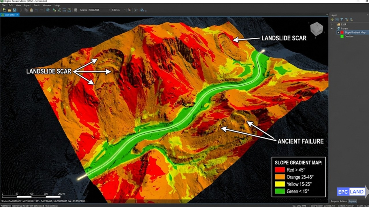
During the detailed design of a strategic export pipeline, the proposed route crossed a 12km section of rugged mountain terrain. Initial satellite imagery suggested a direct path along a valley wall. However, this preliminary route suffered from significant Pipeline Route Geotechnical Uncertainty.
Ground access was impossible for standard survey vehicles due to steep gradients and lack of roads. Sending a foot team was deemed unsafe due to rockfall hazards. Without high-fidelity data, the project faced the risk of constructing on “colluvium”—loose, unconsolidated soil prone to catastrophic sliding during heavy rains.
The Solution: Remote Sensing & Heli-Ops
To solve this “Inaccessible Terrain” problem, the EPC contractor deployed a hybrid survey strategy:
- Airborne LiDAR: A heavy-lift drone flew the corridor, stripping away the vegetation digitally to reveal “hummocky terrain”—a classic signature of ancient landslides not visible in 2D satellite photos.
- Heli-Portable Geotech: Based on the LiDAR data, light-weight drilling rigs were flown in by helicopter to spot-check critical locations.
- Interferometric Synthetic Aperture Radar (InSAR): Satellite data was analyzed to detect millimeter-scale ground movement over the past decade.
The Discovery: The data confirmed the valley wall was an active “creeping landslide” moving 5cm per year. Laying a pipe here would have guaranteed a rupture within 3 years.
Project Impact & ROI
The survey data forced a major Route Re-Alignment to the opposite ridge line, which consisted of stable bedrock. While this added 2km to the pipeline length, it eliminated the geohazard risk entirely.
EPCLand YouTube Channel
2,500+ Videos • Daily Updates
Frequently Asked Questions
How do engineers handle Right of Way (RoW) Acquisition Issues when landowners refuse access?
What is the difference between SUE Quality Levels A, B, C, and D?
How do Environmental Impact Assessment (EIA) Constraints affect route selection?
Why is identifying “collapsing soils” part of the survey scope?
De-Risking the Route for 2026
Successfully navigating Pipeline Route Survey Challenges requires more than just measuring distance; it demands a holistic integration of geophysics, law, and environmental science. By proactively identifying hazards—from urban utilities to alpine landslides—operators can transform uncertainty into engineered assurance.
© 2026 Epcland Engineering. All rights reserved.

Related posts:
![High-grade industrial Wing Nut Types and Applications for mechanical assemblies.]()
Wing Nut Types and Applications: The 2026 Engineering Guide
![Industrial Monorail Crane Systems installed in a modern manufacturing plant 2026.]()
Monorail Crane Systems: Design, Types & 2026 Standards Guide
![Lead engineer performing a Factory Acceptance Test FAT on an industrial skid system 2026]()
Factory Acceptance Test FAT: The 2026 Engineering Guide to Zero-Defect Delivery
![Professional engineering workspace showing a Basis of Design document layout for a 2026 project.]()
Basis of Design: How to Write a BOD for Engineering Projects in 2026
![Industrial Flare Knockout Drum Sizing and installation in a refinery relief system.]()
Flare Knockout Drum Sizing: Design & API 521 Standards (2026 Guide)
![Advanced Reboiler Control Systems in a modern petrochemical refinery 2026.]()
Reboiler Control Systems: Engineering Guide to Precision Control 2026